|


|
|
Hurtigruten Day 5: Harstad - Finnsnes - Tromsö - Skjervöy
Harstad 06.45 a.m., the steamboat has landed. Except for the early risers, during the demurrage time in Harstad, a new Hurtigruten-Day starts for most of the passengers. Undoubtedly, the highlight of the day will be the stay in Tromsö. But until then, first there is to navigate through the fjords and sounds, which beautiful landscapes make stir somebody's blood. It is also possible that today, the passengers are invited to a visit of the bridge. With its protected port, Harstad is the trade and economy centre of an island world around the biggest Norwegian island, Hinnöya. The hinterland of Harstad has 23.000 inhabitants, but the downtown has only 6.000 inhabitants. The economic boom and the receipt of the municipal law in the year 1904 was based on huge flocks of herrings at the coast and on the fertile hinterland that was used ariculturally. Today, there are the most northern strawberry fields of the World. The harvest is done in August. 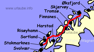
One wonders involuntarilly how do the Norwegians get such delicacies? The most important condition is, of course, the mild climate of the gulf stream and the bright nights do the rest. In those latitudes, the midnight sun shines from may 23rd to July 22nd. The plants are very happy about that! Today, the products of the agriculture and the sea are added by an abundance of industrial products; Additionally, during the past years, the place became a support point of the petroleum industry for the exploitation of the oil and natural gas in front of the Norwegian coast. When the Hurtigrute restarts its way, a few minutes after, the biggest historical attraction of Harstads appears at the portside: the church of Trondenes. The legend tells that here, in the year 999, the first christians of north Norway were baptized and the King König Öystein built at this spot a church of wood in the 12th century. The current church made of stone is from the year around 1250. It was obviously built as a fortification church, as its walls are of a thickness of 2,5 m. In medieval times, it was the most northern stone church of Norway and one of the most important ones in the country. Moreover, Trondenes was a thingplatz and the domicile of one of the most powerful viking genders. In this concern, the islands that are located in the north west of Harstad, Grytöya, Sandsöya and Bjarköy, should not remain unmentioned. From here, a lively business was held with the people of Bjarmland, northern Russia today; but the most profit was made with the raids. The last one took place in the year 1222, after that, the Bjarm people turned the tables and started their raids in the north of Norway. )
)
)
)
With so much history and still only a fraction of what is worth to mention, one should not forget the view to the east. There are the islands Rolla and Andörja with their interesting mountain formations, as for example the perfect pyramide of the peak of the Rolla with a height of 926 m. On a winter travel, when there are not so many passengers on board, it can happen that between Harstad and Finnsnes, one can visit the command bridge. But today, the captain and the mate are not standing any more with spread legs in front of the rudder, but sitting in front of the screens to control the navigation (GPS). Absolutely unromantically, the ship is controled with three little buttons. But the sea cards, card tables and compasses are still there. As an exercise, sometimes it is navigated without GPS. Then, hundreds of beacons and navigation marks, as also the experience of the crew, determine again the course of the Hurtigrute. While our stay in the "sanctum", we approached the island Senja. Located at the west of the waterway, it is the second biggest island of Norway and offers a scenical cross-section of the province Troms that we are currently passing. Offside the coast, there are pretty farms, in the western coastal region some little fishing settlements and offshore, the best fish banks of the country. At the waterway of the Hurtigrute there are quiet hamlets, deciduous forests, and a friendly green. )
Once the steamer circumnavigated the eastern tip of the island with the old trade plaza Klöven, Finnsnes juts out the waterway. Klöven has lost its significance as a place of trade when Finnsnes turned to be the embarkation point of the fast steamer. After a short stay in Finnsnes, the ship passes the bridge with a length of 1220 m that communicates Senja with Finnsnes and the mainland since 1972. The trip continues through the narrow Gisund to the north, until the island Kvalöya appears in the waterway so that the course has to be changed to north - east direction. In Kvalöya, there are numerus evidences of the prehistory and the early history, as also petroglyphs that are up to 4000 old. Between Kvalöya and the mainland, one navigates into the narrow Rysstraumen, with 6 bends, it is the fastest tide current in the waterway of the Hurtigruten. Then, the southern tip of the Tronsoronso with a length of 10,5 m and a width of 3 km already appears. On this island, there is the old Tromsö, that celebrated its 200th city anniversary in 1994. Once drew into the Tromsösund, the kyle bridge of more than 1000 m length is already visible from a distance that communicates the Tromsöya with the mainland. In the extension at the starboard side, there is soon the distictive construction of the Artic Sea Cathedral visible; it is the emblem of the city. This architecturally headstrong consruction that was inaugurated in the year 1965, is, with its 11 tent-shaped segments, is 35 m high and according to the idea of the arquitects, it is supposed to represent a new version of the traditional boathouse church. )
)
)
)
We arrived at Tromsö! The ship stays for 4 hours at the dock of this beautuful city that is probably the most beautiful during the winter, that is when an abundance of lights make understand why Tromsö is also called the "Diamond at the edge of the Arctic". This diamond is amidst is located Tromsösund and sparkles. The lights are on for 24 hours, nobody turns off the lights in their houses. A homey, warm atmosphere is over Tromsö and it gets never realy dark, although the sun remains below the horizon from November 25th up to January 21st. If then there is also the gorgeous play of colours of the polar lights are visible above the Artctic Sea City, latest then, also the heart of a "southerner" is warmed (see also the diary of the 8th day). In all seasons, the pure and fresh air of the north is mixed with the scents of the sea, tang and fish. In numerous bars, night clubs and restaurants there is hustle and bustle, as also quietness. At the water, one is surrounded by the continuous lapping of the smooth waves; the chugging of the fishing boat admixes with the loud hoot of the bigger ships and the screaming of the seagulls. There is the most northern brewery (inaugurated in the year 1977 by the german Ludwig Mack) and the most northern university of the world (I don't dare to say if there is correlation), as also the most northern botanic garden. Mostly everything is the northest in Tromsö. Only the city itself cannot adorn itself with this plume, as this honour dues Hammerfest. But therefore, 627 islands belong to the city area and with its 2.558 square kilometres, it has a surface that is five times bigger than the capital Oslo. Curtly 56.000 people live on this surface, therefrom, approximately 16.000 right in the downtown and the suburbs of Tromsö. From the beginning, Tromsö was an important place for trading, ship and boat yards, fish exports as also the equipment of polar expeditions dominate the economical life of the city. The real anthesis started at the end of the 18th century, when it was possible to loose the economical bonds of the overpowering Bergen. In the year 1960, a new time began for Tromsö with the aperture of the kyle bridge. It is a prototype of a series of big Norwegian bridges, that were built in the course of the following years after this model. During the last decades, the connection with the mainland played an important role for the economical development of the city. Earlier, it was called city tour and today, the Hurtigruten keeps up with the times and offers a sightseeing tour Tromsö. If the number of participants is adequate, this excursion is offered the whole year through. )
)
)
)
But one can also easily head out on one's own bat, for example, by walking up straight from the quay to the city, the monument of the south pole conqueror Roald Amundsen is on the way. The cathedral of Tromsö, that is one of the biggest wood churches of the country, follows. Further to the right to the pedestrian zone of the Storgate, the main street of Tromsö, surrounded by old houses. At the end of the pedestrian area at the right side, one get to the Tromsö museum with its scientific exhibitions about geology, botanic and arqueology. The polar museum is still in the range of vision, that shows exhibitions about Roald Amundsen and Fridtjof Nansen, as also the significance of the polar region for Tromsö. From here, it is not far any more to the kyle bridge, over which ine gets to the Arctic Sea Cathedral. If the weather is fine and the visibility is favourable, one should consider taking a taxi that drives one to the lower terminus of the gondola lift of the 420 m heighted Storsteinen. From there, one has a view that is equivalent to the one of the Flöyen in Bergen and the Aksla in Alesund, yes, it probably beats them. But despite of al this, don´t forget the time! It would not be the first time that one misses the ship in Tromsö! At 06.30 p.m., it says again "Leinen los". In the winter, thousands upon thousands of lights accompany the navigation of the ship at the left and the right of the waterway, until the last suburbs of Tromsö are left behind. At bright summer nights, between Tromsö and Skjervöy (arrival at 11.00 p.m.) at the starboard side, the massif of the Lyngen mountains shows up. A climbing paradise with peaks heighted more than 1500 m. The central european alpinist who is used to mountains heighted from 3000 to 4000 metres, will probably sneer. But he should consider that these 1500 m poke right from the sea and therefore, they are absolutely comparable with the huge Alp peaks. 
Back to the index Norway-Hurtigruten Author: Manfred Hofmann; Copyright: Patrick Wagner, www.tourist-guide.biz |
||