|


|
|
Drive through the Massif Central of Gran Canaria
During the drive through the Massif Central of Gran Canaria, one lives the most spectacular tours of the island if not the most spectacular one at all. Gran Canaria suddenly presents itself from completely different sides, so that one has partly the feeling of being on a totally different island. Specially the brightly green, almost wildly sprawling plants in the north-eastern centre of the island all around Vega de San Mateo that we passed during our trip back have nothing to do with the scant brown Gran Canaria we know from our tour through the eastern and the southern coast. Here, one really cheers with the flowers and bushes that colourfully rise in the warm rain. It seems there is enough rain and humidity in this area of Gran Canaria. 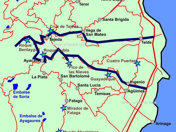
This must be also considered by leaving for the tour in the south and the sun is shining there. In the mountains, not only the temperatures are considerably lower, but also the wind and rain conditions can unpleasantly surprise soon. Specially the drive to the three highest mountains of Gran Canaria in which one looks forward to some fantastic views form a distance and a spectacular panorama, one has to expect that it occurs relatively often that the typical foehn clowds appear. This spectacle looks fabulous from a distance, when the mountain tips are completely surrouinded by a wave of cotton. But once being inside this cotton clowd, there is rather the effect of a milky soup where all shapes and colours seem to disappear. Due to this reason, one should get prepared. As much as the sun can radiate at the coast, up there, one will soon feel like crying without having some warm and weather-proofed clothes. 
But we do not want to get too pessimistic soon. At the highest point of Gran Canaria, for example, at the Pico de las Nieves, we had a wonderful view at an altitude of 1949 metres to the Teide up to the neighboured island Tenerife. During the further drive to the Roque Nublo that is not far at the west of Pico de las Nieves at approximately 1800 metres, this area unfortunately disappeared in the clowds. But instead, the view further to the west at the Roque Bentayga at 1400 metres was again nicely clear. then, one has to stay serene and hope to be a little lucky. 
Serenity and good nerves are also needed on this stretch for driving. Up to Pico de las Nieves, the roads are wide and lead withoput any complications up the mountain. Inside the Massif Central, things look differently. if one wants to explore some smaller mountain villages as for example La Solana or El Chorrillo in the proximity of the Roque Bentayga, then one should be able to manage the gear change with flexibility, as the narrow serpentines without any fixed markers require a lot of concentration and driving ability. It almost does not matter where one starts from, as one gets to the centre of the island from everywhere; We first drive from the south on the motorway to Ingenio. From there, the driving time to get straight to Pico de las Nieves is of 45 minutes. By air lione, Roque Nublo seems to be at a very close distance from Pico de las Nieves. The drive takes approximately half an hour.The way to Roque Bentayga over Ayacata is more labiourious. We circulated Roque Nublo until we got, after a lot of serpentine curves, to the cultic places and caves of Roque Bentayga. Also the further stations Tejeda and Cruz de Tejeda are physically close to each other, but timewise one has to calculate much more due to the curves. But therefore, the stretch repeatedely offers a nice panorama into the wide canyons and the variegated vegetation. Ingenio: Tour Start in the east to the Pico de las NievesWe start our tour from one of the southern holiday resorts and after a drive of approximately half an hour, we have our first stop in a small place named Ingenio. Ingenio is a nice small place at the east of Gran Canaria approximately located at the level of the airport. 
Those who want to visit the centre of Ingenio and not only use the central road GC-120 for driving through will be pleasantly surprised; At least we were. Even though the place right in front of the church seems to be partly deserted, the facilities around it are nicely arranged with love to the detail. 
Several fountain arrangements are surrounded by nice green meadows and flower beds. A door leads to a small green park that is also a playground at the same time. From the forecourt of the church that appears in total very open and generous without being covered, as it is the case in other places, by numerous small streets or alleyways, there is even a view right down to the sea. Here, it was very relaxing to get out of the car for a short time and walk a little. There are also public toilets right at this plaza. it does not take much time to view Ingenio. By parking right at the church, one walks up and down for a quarter of an hour in order to see the small city centre. 
During the further drive after Ingenio, there are no places worth to mention. Thus, it is possible to start straight away up to Pico de las Nieves and just enjoy the drive. The road conditions remain relatively wide up to the mountain tip and it is quite easy to drive on them. There is repeatedely the possibility to stop, look down the hillsides and gaze at the pine forests. These views are specially fascinating if one can look to the clowds from above. Pico de las Nieves: Highest Mountain of Gran CanariaPico de las Nieves is with its altitude of 1949 metres the highest mountain of Gran Canaria. Actually, it cannot be described as a real mountain, neither from the respective mountain peak, but as a relatively flat area on which the military and TV station mark the picture. 
What already appears not to be very attractive from a distance, also provides during the approach a miserable coulisse. The area there is completely covered with radar stations and antennas, and the prohibited area is surrounded by high fences secured with wires. But despite of this, one as a dream view from three view points and, depending on the weather, one is right above the clowds. The original name for the highest place of Gran Canaria, Pico de las Nieves (snow-top) or also Pozo de las Nieves (snow-fountain) hardly cope with the actual aspect on the spot. Currently, the peak is rarely covered with snow and the coulisse of today is marked by the two white radar balls so that even after the official street signposting it is named 'Los Pechos' what means in translation 'The Breasts'. 
Up to the end, the drive to the Pico de las Nieves is very well signposted. First, one gets to a smaller parking place at the edge of the road where the road forks to two further view points. But the best is to get our of the car in order to get orientasted and enjoy the first sight. Those who have driven the whole way from their holiday resort at the coast without any interruption will first get a cold shock up there. While down the coast there are some pleasant 25°C, at a height of 2000 metres, there are maybe 5-10°C. 
From here, one also has a fantastic view in southern direction. The canyon of Fataga at the front can be viewed up to the coast of Playa del Inglés. It is exciting to see from a distance how each of the curves and mountain roads run. By this way, one can for example see the curvy stretch that communicates the places San Bartolomé and Fataga in the centre of the island. Considering that Gran Canaria has a diametre of not more than 50 km, one is really amazed by the time needed for these distances due to the reason one has to get repeatedly up and down the mountains. 
Beside this spectacular view, there is also a ruinous fountain at this spot. it is an imitation of the snow fountain of the 16th century. When there was still no electric supply in Gran Canaria, the inhabitants used the altitude to conserve snow and/or the snow converted to ice in order to sell it. 
At the Pico de las Nieves, one can look to different directions of the island from several view points. By turning to the east at the road junction, one gets to the view point Pico de la Gorra. The antennas rising to the sky do not provide a romantic view on the drive to there. On the map, Roque Redondo is actually marked at a height of 1919 metres as a further point. By car, one does not get further than from the Pico de la Gorra, as continuing driving is restricted by the signpostings. From there, one enjoys a view in direction to the east to a small picturesque lake we already passed duringour drive from Infgenio, but on the map, there is no name mentioned for it. Also the small city San Bartholomé at the south is visible from here. 
But the actual attraction of Pico de las Nievesis not discovered before continuing driving to the actual view point. One should not get deterred by the previously described military fence. It does not get really deterring until one sees the numerous buses parked in front of the souvenir shops. Latest now, one notices that one is at THE tourist attraction of Gran Canaria. We did not see anywhere else such an abundance of buses at once. We really had to jostle against each other in order not to stand shoulder to shoulder with the immediate neighbour while making pictures. but therefore, the view from here above was really unique. 
First, our view fell to the two rocks Felsen Roque Nublo and Roque Bentayga located in the proximity. We then discovered the Teide of Tenerife at the horizon. We indeed knew in advance that from here it was possible to look up to Tenerife, but the way the >Teide majestically rised out of the clowds really fascinated us. 
From this view point one can look over the clowds. Thus, those who are not deterred by the rush of masses will surely enjoy the view. For those who prefer less hustle and bustle, the same view from Mirador de Becerra is recommendable. Even though the view point is not as high as Pico de las Nieves liegt, the Teide and the mountain world around it are clearly visible. 
The Mirador de Becerra was not straight within our tour but is located on the GC-150 at the south of Cruz de Tejeda. Here, a café with an appendant museum of geology is located in a little hidden way. Roque Nublo: Rock Finger and Emblem of Gran CanariaIt takes half an hour up to 45 minutes to get to Roque Nublo. Roque Nublo is a rock that rises up to 1800 metres and that due to its shape of a thick rock finger it is frequently visited by the vacationers of Gran Canaria. Those who try to recognize the Roque Nublo from a distsance might be confronted with a brainteaser. The monolith that is described as a rock finger in the travel guide results to be in reality a very knobby rock finger. We first confused it with a narrow grout that was in the right proximity. 
One first drives on the GC-130 further in northern direction and turns then to the GC-600 in direction to Ayacata. The parking place that belongs to Roque Nublo is relatively small, as from here, some hiking tours start. Here, I do not want to miss to remind on weather-proofed clothes. The foehn clowds can make one feel really cold. Even though at the start there were pleasant temperatures at the coast, the winds during the foehn and the wet-cold air are a guarantee for future colds. Up here, there are also in the summer time temperatures of only a few grades. 
by wearing sturdy shoes and enough warm clothes, walking here above is real fun. It is easy to walk on the paths and the walk to the Roque Nublo is also not far from the parking place. With the destination of excursion Roque Nublo things are much different than with Pico de las Nieves. 
Even though many tourists oftenly get to this place, one will hardly see that anyone gets out of the bus in order to walk some steps; People rather get on their own to this place in order to take the opportunity for a short hiking tour, as the area around the rock is the actual attraction. The view from the parking place isn't worthwhile for the quick consumption. Thus, at Pico de las Nieves one mainly comes across to tourist buses, at the Roque Nublo rasther small rental cars. Ayacata: Crosspoint at the Massif CentralRoque Nublo is only at some minutes distant by car form Ayacata. Ayacata remained in our memories rather as a station in the proximity of the Roque Nublo or as connection and crosspoint in the centre of the island. The small place that is rather a collection of houses offers a good restaurant, the La Candelilla, that is used by many tourists and local people as a stop ion between. Here, one can also sit outside if the weather is fine. Ayacata does not have the same glorius character as the crosspoiont at Cruz de Tejeda, that is simirlarly centrally located but further to the north; Anyway, it has to be passed if one wants to connect the canyons of the south in one tour. From Ayacata, our tour continues to Roque Bentayga. the tour continues contraclockwise in direction to Tejeda on the road GC-60 permanently around the Roque Nublo. The views are repeatedely fascinating and one can use the small bays at the road for one or two small stops in between. Roque Bentayga & Cuevas del ReyRoque Bentayga and Pico de las Nieves and Roque Nublo are almost nemed in one breath if the topic is about the highest altitudes of Gran Canaria. With 1412 metres, it is the number three of the most interesting mountains within the Massif Central. 
Beside the fantastic distant view that is available here, the actually interesting thing of the Roque Bentayga is in its interior and the places around it. Being aware of the significance the Roque Bentayga had to the aborigins of Gran Canaria, the monolith reminds one, also form a distance, on an over-sized altar. 
During the drive to the Roque Bentayga we can say we were lucky that no bus came in opposite direction. The road condtions are certainly wide enough, but there are no crash barriers and at the edge of the road there is a steep precipice. For those people who are tired of life, this might be very exciting, but we rather found this a little frightening. 
The drive requires a lot of concentration. The road leads up to a parking place. Before continuing on foot to the actual Roque Bentayga, the archeological museum can be viewed where the area and each of the historical meanings of it are excplained. Unfortunately, this explanations can be only read in Spanish language. A café or a restaurant does not exist up here, but therefore, one can use the dapper toilets before the walk. The entrance to the museum is free. 
The way up to the cult place of Roque Bentayga leads through a narrow path that goes relatively steep upwards. Even though one does not have to plan more than one hopur for the way to there and back, depending on one's fitness, the path can be a little exhausting. but it is worthwhile! Beside two caves and the cult places where one can still see some grooves in the ground, the view to the surrounding area is simply breathtaking. 
Actually, the whole area all around the monolithes belong to Roque Bentayga. By this way, one also sees the Cuevas del Rey right from the road. The caves are relatively highly carved in the steep cliffs. Underneatht the Cuevas del Rey there is the small residentail place El Roque from which it is not possible to continue. On both pictures at the left edge there is the small group of houses El Roque arranged between two of three rocks rising up. 
It is hard to believe that still now people live there. But one should not think there is something to discover there, as one finally gets to a one-way street in El Roque and has to turn there and/ior continuing driving on the road to the two small mountain villages La Solana and El Chorrillo. 
The caves around El Roque are certainkly used still today for storage, but a visit is not possible any more for tourists as the way to the caves has not been reniewed any more. For us, it was enough to see the caves from the street. La Solana, El Chorrillo: isolated Mountain Villages in the LonelinessIn some travel guides one can read that a side trip to these two mountain villages is worthwhile. We did not have the same opinion, even though on the way to these villages one has a beautiful and wide view to the hillsides; Right at El Roque, the road forks to the two small villages. We underestimated the distance on the narrow serpentine road a lot. On very narrow and very curvy serpentiones, the way seemed to be endless. as the roads were certainly tarred but not fixed, the drive was really labourious. Due to the abundant rockfalls, there is a lot of boulder on the road. 
One had to highly concentrate in order not to steer by mistake abruptly too much to the right and fall steeply down the hillside. There are certainly only a few kilometres up to this small mountain village but with an average tempo of approximately 20 km/h, also small distances are eternal. 
Finally, here is not anything special to see. The thing that impresses one is the complete isolation in which people still live here. This is probably also the impression one get from here; Not the arquitecture of the houses not the people one passes on the street with the car, but the huge distance that has to be taken up to the next city. It is amazing how luxurious the own facilities at home suddenly seem to be! In Gran Canaria there is a strong migration into cities since some decades: the inhabitants of such tiny mountain villages increasingly leave their houses so that only ghost villages are left. This is certainly still not the case in Solana and El Chorrillo, but the tendency exists in the island. In former times, the inhabitants of a village got married with each other, even within the family, as the uinhabitants almost had no contact to the outer world. Today, there are connections with other towns through the small roads, although the way to school can take one hour. Tejeda: Picturesque Mountain Village with a vivid Tourist LifeTejeda is a small mountain village at an altuitude of approximately 1000 metres and is located at the hillside of the same-named canyon. In the travel guides, Tejeda is described as specially picturesque. From a distance it almost looks like the houses are shiny white. 
Within the place, one has a good view to Roque Bentayga from the road that runs alongside the mountainside that leads as a promenade alongside the centre. But one thing really suprised me: the abundance of big information boards at each corner indicating where to find what. They did not really match into the picture of this small place. 
We certainly knew that it is possible to get something to eat at Cruz de Tejeda, but the first time we drove this stetch we were so hungry that we stopped at the first restaurant we discovered in Tejeda. In this restaurant named La Perdiz we sat on rusty wood chairs felt slightly cold and the American oldies of the 60ies that were playing did not really warm us up. 
The dish of the day, paella, was certainly good, but the chicken leg with the side dishes was only good in order to satisfy the hunger without having a special experience of taste. In total, it was ok for a short rest and very cheap compared to the restaurants at Cruz de Tejeda. 
One gets tired from the long drive through the mountains, also hungry and thirsty. Those who want to have some good food should drive up to Cruz de Tejeda. Those who simply want to rest and have cheap food should have their break in Tejeda. Cruz de Tejeda: Crossing Point at the Mountain PassCruz de Tejeda is a pass cross at the north where the ways to the Massif Central cross. First, we found the atmosphere like in a fun fare. Chicken were freely running everywhere. In the proximity of the cross there were some market stands with any kind of coloured souvenirs, food and local products. Only by looking closer at it, this place resulted to be a small insider-tip. on one hand, here the Hotel Parador de Cruz de Tejeda is located. Paradores is a spanish hotel chain specialised in offering a service at top level and some comfort in either a rural as also a traditionally unique environment. 
on the other hand, the Asador Grill de Yolanda, a barbecue restaurant with a bar, resulted to be a culinary highlight. We were certainky shocked by the high prices, but therefore we can compliment the location and the food on highest level. 
From a small but well heated upper floored terrace one has an ewxcellent view all around. The interior is cozily decorated with wine bottles and any kind of vegetables hanging from the walls. Also the longue music put us immediately in a cozy atmosphere. The gambas and all the other ingredients tasted very fresh and delicious. 
One should pay attention not to get the "Tourist Card", as then we could have only ordered big dishes. Not until we asked several times very straightly, we could order the typical small tapas that were mentioned in the other card that got the spanish speaking persons. Unfortunately, this reduced a little our good impression of the restaurant; Even though the food was really good, I do not want to be obliges to take one of the day dishes offered for a lot of money. 
Thus, those who want to have a lot and good food will be here in the right place; Those who have to take care of their budget should have a look into the menue card before ordering. Trip Back over Vega de San MateoCruz de Tejeda is our last highlight during our tour through the Massif Central of Gran Canaria. Now we return to the south. There are several ways back from Cruz de Tejeda, all take barely half an hour. I can recommend the drive in northern direction over Vega de San Mateo, as in this tour, one learns a completely different side Gran Canaria that is a very green one. The drive over the north is certainly a small detour as first one has to drive in opposite direction, but therefore one gets sooner to the motorway and from there, one is back to the south of the island in half an hour. As I already wrote in the beginning, during the further drive through Vega de San Mateo I was reminded on leafy islands as for example La Palma. The vegetation in this area growths so much that the picture is mainly marked by the agriculture: fruit tree plantations, grape-vines and vegetable fields almost made one think of home if there were not repeatedely oleander trees., palms and cacti appearing in the picture. The plants try to sprawl into the road from the left and the right side; it is hard to believe Gran Canaria can be so green. Here in the north-south there are the most rainfalls of the island. Almost throughout the year the trade wind clowds get accumulated here and release their humidity to the nature. Thus, here is an abundance of rain and these are optimal conditions for the growing of the plants. Those who do not experience this north-eastern part of the island will evaluate Canaria as a dry island without many vegetation. Those who visit this place will afterwards like to remind the many green areas of this trip.
Back to the index Gran Canaria Copyright: Patrick Wagner, www.tourist-guide.biz |
||