|


|
|
Tour through the canyons in the south of Gran Canaria
With the tour through the canyons in the south of Gran Canaria we already viewed three bigger canyons in a more extended tour. enjoy each of the stations. As we did not get out of the car in any place in order to do a hiking tour or to spend long time there, we could get in relatively short time a spectacular impression of the bizarre world of the canyons of Gran Canaria. In the car, one needs to be patient with much too prudent drivers in the partly very steep serpentine roads. At many places, there is a speed limit of 40 km/h, but this is a good thing as in many spots, one cannot see what is behind the curve. 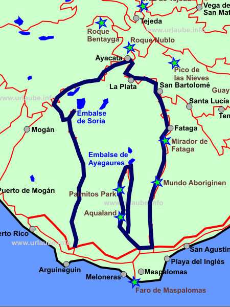
The distinctive thing of this tour is not only the view to some cliffy rock reliefs but also the many view points are beautiful from which one reppeatedely has a wonderful panorama view to the mountain world of the centre of the island, or, if lucky, up to the coast. The many bigger and smaller reservoirs are specially excellent, to which one can partly only get by foot. Two hotels we found amidst the mountains specially fascinated us, so that we felt like getting accommodated there immediately. One surely does not need to make the same way in the same order the way we did it. Actually, many single spots are much too beautiful in order to pass them quickly. The hiking lovers would surely also want to live more intensively each of the stages. We started at the south on the GC-505 in order to get to the reservoir of Soria. From here, we made a small side way to the left alongside the view point Cruz de San Antonio over the GC-605 to Ayacata. The whole of he stretch up to here is merely outstanding by irts fantastic panorama. There is hardly a bigger place appearing on the way, neither any tourist attraction. This is just the fascinating thing of this stretch; Not until we left Ayacata long ago in direction to San Bartolomé we noticed that there are also other tourists on their way. From Cruz Grande, a popular view point, several hiking tours start so that the parking place was full of cars. San Bartolomé de Tirajana is the first biggest city from which it gets further to the south over Fataga in direction to the coast; With the Mundo Aborigen, a park that informs about the aborigins of Gran Canaria, there is also some culture on the drive in between. Those who after this stretch would have enough would have the possibility to take the motorway and to end the day at the sea. We decided to take the smalll round tour to Embalse de Ayagaures. By this way, we passed on the GC-503 the bathing fun park Aqualand Maspalomas and the Palmitos Park. Embalse de Soria: A dried Reservoir in an amazing LandscapeWe start our canyon tour from the holiday resort Maspalomas and drive first a piece further to the west up to the place Arguineguín. There are only a few kilometres up to Arguineguín that can either be rapidly made on the motorway or one drives alongside the coastal road and repeatedely enjoys the views down the coast and passing some rocky landscapes and small beaches.

The high wall of the reservoir makes suspect a huge lake. But the picture behind it is completely different. At the time we were there, the lake only had few water although the winter time was recent. The road that continuously became more narrow ended at a kind of turnaround where one can park and from where it is possible to make some hiking tours. We drive a piece back into Soria. at a street corner, there is a small restaurant where it is possible to park. From there, one can walk in a few minutes down up to the wall of the reservoir and look straight to the lake and/or the valley behind it. 
On the way back, at the city limit of Soria, at the level of Banquillo Andrés, there is a signposted road to Cruz de San Antonio. This is not a road numbered on the map but rather a small country road that ends in the further course into the GC-605. Cruz San Antonio: Marvellous place that still has to get restored from the firesThe tiny road from Soria to Cruz San Antonio is a highlight for those people who enjoy driving. The road is very narrow and curvy, so that one always thinks that the end ofn the road is coming soon, but it isn't. The road is permanently tarred, it is possible to slowly drive up the hill with a normal car and finally get to Cruz de San Antonio; As this road is not properly represented on any map, one practically drives alone, can have a stop at any time and does not have to avoid continuouskly the opposite traffic. 
At first sight, the rest area Cruz de San Antonio appears as every other one. but then this area results to be a wonderful place with meadows on which children play football and the campsite as a 'Zona Recreativa' as a real leisure area. The relatively leafy hills on the drive back are much nicer to look at than the bald cliffs. During the further drive from Cruz de San Antonio, the road GC-605 curls alongside a wonderfully curved lake. The Embalse de la Cueva de las Ninas is located amidst a wonderfully green field surrounded by some smooth hills. Much different as it is the case in the Soria lake, the view is mostly possible from the road, and one really starts to adore this landscape. Unfortunately, there must have been some heavy fires before, as some areas with burned bushes and trees demostrate. 
On this stretch, one does not notice at all that Gran canaria is an island opf mass tourism. During the drive in this area, one is almost alone in this marvellous nature. Ayacata: Short Stop in between in the Restaurant La CandelillaDuring the further drive to Ayacata, the landscape gets continuously drier and scant. There are no green spots, but therefore, the more altitute we gain, the more profile get the rocks. 
In Ayacata we made a rest and went to the restaurant La Candelilla. Here, we were happy to get a seat in the interior, as in the beginning, all tables wer accupied. From the outside, we did not expect such a brisk business and that all people involved were in such a good mood including the hosts. apparently, this restaurant is an insider tip. The small restaurant is arranged in a simply rustic style; in the entrance area, there is a small souvernir-shop. The food was good and cheap. 
From Ayacata, it is not far to the Roque Nublo, a rock that rises up to 1800 metresthat due to its shape like a thick rock finger, many vacationers of Gran Canaria like to view it. 
On the GC-600, it is only a small distance to there from Ayacata. We have viewed the Roque Nublo during another tour. Together with the highest mountain Pico de las Nieves or the Roque Bentayga, we describe the drive to Roque Nublo in the chapter about the tour through the Massif Central. The View Points La Plata and Cruz GrandeInstead of getting further to the north to Roque Nublo, from Ayakata, we continue on the main road GC-60 in direction to San Bartolomé. Approximately in the middle of the stretch between Ayacata and San Bartolomé, the view points are La Plata and Cruz Grande. 
A few kilometres before the Cruz Grande, La Plata appears on the way. From here, it is possible to see the Embalse de Chira that is located at a far distance, the neighboured lake of the reservoir Soria that is only accessible over a small road. The coulisse almost reminds on idyllic scenes from the storybook, although the lake was very tiny from the distance. 
In total, we were nearly more impressed by the view from La Plata as by the view later on from Cruz Grande. After all, from Cruz Grande, one has a fantastic view at a height of stately 1251 metres to the mountain world behind one. Maybe it was also the emerging hectic that slightly spoiled our mood to the view at the Cruz Grande. This point with the appendant parking place serves as a start for several hiking tours into the most different directions. Insofar, one has to expect a brisk business at this place. Aldiana Mirador: Wellness-Hotel with a fantastic viewLocated at a height of approximately 1000 metres still before San Bartolomé, there is the country hotel Aldiana Mirador. We were really fascinated by this excellent and calmed location. Everybody is allowed to enter the hotel and right beside the reception there is a small observation deck with tables and chairs from which one has a fantastic panorama view to the Central Massif of Gran Canaria. Right unerneath the observation deck there is a steep precipice. 
Even though at this height, the temperatures are not so warm and apt for bathing as it is the case at the south coast, the situation is perfect for those who want to relax or hike. With this panorama view we could enjoy from the terrace, we specially felt like taking a room in this hotel in order to stay there for a couple of days. The spa- and wellness atmosphere was clearly noticeable, simply because in total, it appeared to be much more quiet than the business of the hotels at the coast. 
Unfortunately, the restaurant was not permanently opened, so that we could not have a snack here. otherwise, such a panorama restaurant is of course a highlight for a good lunch at the mountains of Gran Canaria. We of course do not know how a stay here would have been in total. The arrangement and design of the reception area with the appendant friendly personnel anyway had a very nice impression to us. San Bartolomé: A short stop in between in the Restaurant El RuralSan Bartolomé is a small place that is located on the way of different tours. We were a couple of times in San Bartolomé, also during the tour described here. 
Despite of the over-sized appearing church and the relatively abundant restaurants right on the street, the small place apparently has only an historical significance, as from here, all important decisions for the touristical development of Gran Canaria were made. Surely, this rather depreciatory estimation of San Bartolomé is not totally just, but the typical vacationer at the coast will surely not be enthusiastic for having some long walks through this place. One simply drives through this place, and if hungry, does a stop here in order to get something to eat.it takes maximum a quarter of an hour to view this place in order to see some nice houses and a church. 
As places of accommodation in this place are rare and in the travel guides they are also only roughly described, here, one rather comes across to some cyclists or some ambitious hikers. We got this impression during a small snack in the Hotel Restaurant El Rural that is located right at the main road that leads through San Bartolomé. From the outside, the big and yellow building appears to be very cozy and the typical Canarian specialities were very tasty. The best is to park on the parking area that is located diagonally opposite to the hotel, as in San Bartolomé it is only possible to park in a restricted way. Country Hotel for Families: Molino de AguaAnother inconspicious hotel impressed us during the further drive from San Bartolomé to Fataga. Shortly before Fataga, the country hotel Molino de Agua is located. a big signpost indicates the country hotel, which complex is freely accessible for visitors. 
Right after getting out of the car in the parking place, we could already smell the tasty barbecue. The whole complex is spread over a naturally dapper green belt. We passed an open air café and arrived at a nicely arranged playground for children with an integrated zoo. Beside chickens and newborn small goats, there are a lot of birds, thereunder also colourful peacocks. The small hotel only has 32 beds in total; The complex with the pool located between some palms is in any case something for individualists who enjoy the feeling of being 'among themselves', in order to relax. 
The small side trip to Molino de Agua took half an hour but it was a nice smalll viewing of the country hotel and the complex around it. Fataga: Small place with a lot of charmFrom Molino de Agua there are only a few minutes up to the place Fataga. Meanwhile, we also arrived at the same-named canyon Barranco de Fataga and will return from it back to the south. 
The small place Fataga pleasantly surprises one. In some current travel guides we read that in Fataga there is almost no attractive infra structure for tourists. we cannot confirm this. 
the small city Fataga offers everything what the tourist needs for the drive through; Gas station, toilets, souvenir shops, mini-supermarket, restaurants and even an arts gallery. In front of the church, the forecourt with benchs and stairs offers the posibility to have a seat at the shade and enjoy the nice atmosphere. Only the biker meeting that took place just at the time we were there took us a little out of our calmness. 
Anyway, we felt like staying there for a longer while. We loafed through the alleyways and were really impressed by the claddings of the small houses made of natural stones and partly coloured in white. Fataga has recognised its strategically convenient situation and is arranged as a station for the tourists. 
Finally, a lot of tourists enjoy to have here a small break from the drive by coming up to the Barranco de Fataga from the south, before continuing driving up the mountain. And we also had made a lot of kilometres before finally arriving to Fataga and having still much more kilometres to make. Mirador de Fataga: A very special View pointThe whole drive back to the coast through the Barranco de Fataga is a panorama stretch with some fantastic views down the valley and up the canyon. A highlight is the view point Mirador de Fataga where one should not miss to have a stop. 
This view point is a big rondel that is rushed by swarms of tourists wanting to make pictures. But in any case, it is worthwhile to stay here for a while. We got out of the car at this place on two different days. When the whole mountain scene was covered with foehns, the whole view became even more beautiful. 
With a higfh visibility, it is possible to look up to the dunes of Maspalomas and/or Playa del Inglés. It seems the sea is right in front of one, but it is still a half an hour's drive from the Mirador de Fataga up to the sea. But the special thing is still the view into the canyon that is now right in front of one. 
The many smaller serpentines that are visible at each of the hillsides are oftenly driven by jeep-safaris. We could not get enthusiastic for this way of exploration of the island. Specially due to the partly cool temperatures a tthe mountain altitudes, the people in the jeeps wearing only a t-shirt seemed to be very cold. Mundo AborigenThe open air park Mundo Aborigen is located right at the road to Fataga. Those who do not have a problem with paying 10 euro entrance fee, will get some spectacular simulations of scenes of the Canarian life of primitive times. Live-sized dolls show the life of the Canarian aborigins. 
The village life is represented by a butcher, a peasant and even some rudimental medical interventions and an execution. The theme park is underlined by voices and noises coming from a tape. the life and the daily life is explained in several different languages without getting much too fabulous. Almost all areas of life form living in a house to ritual cults up to the labour life are authentically reenacted. Of course, beside the park there is additionally a restaurant and a shop where one can purchase some souvernirs from the park. 
But the entrance fees are still much too highm as at the canyon of Pataga there are so many views to see for free. Thus, one can confidentially skip the Mudno Aborigen and get straight away down to the sea. But the drive of Fataga up to the coast and/or the way around is not as straight as one might have expected it to be. On many serpentines, the way leads repeatedely up and down the hill. In total, the drive from Fataga up to the coast took 45 minutes. Leisure Park: Aqualand Maspalomas, the former Aqua SurAs that day we had still some time at our disposal, and we were still not satisfied from viewing canyons and views, we drove from the south coast right into the neighboured canyon of Ayagaures and soon pass one of the big water parks of Gran Canaria. 
In the area around Maspalomas there are two big water parks. The Ocean Parc is located in the proximity of Playa del Inglés and the Aqualand Park at the upper side of Maspalomas in direction to the Palmitos Park. Both parks offer countless pools for splashing and swimming and of course also countless slides. We did not visit any of them. We found the prices exceeding 20 euro deterrent, although the view from the parking place to the endless slides partly curved in a spectacular way really impressed us. These parks are arranged in a way people spend the whole day there. It is big fun for families. But isn't it possible to have as much fun on the beach for free? Palmitos Park: Unfortunately closed since the fire in 2007During the further driving into the canyon we get to the Palmitos Park. On more than 200.000 square metres, a huge subtropical park has been arranged with the Palmitos Parkin the Barranco de Palmitos. Beside the subtropical plants as palms, cacti and orchids it is possible to see in different sections some exotic birds, reptiles or monkeys. Additionally, there is a dressage performance of birds of prey or reptiles several times a day. We had to take this information from the homepage of the Palmitos Park because it was still closed since the heavy fire on June 2007. Embalse de Ayagaures in Barranco de los PalmitosOnce having passed the leisure park Aqualand, the street forks to the reservoir of Ayagaures. One can decide in which direction one wants to drive through the canyons through which both roads are leading. At the left, the GC-503 leads through the Barranco de los Palmitos and to the right one can drive in contraclockwise direction on the GC-504 first through the Barranco de la Data. 
We take the first option. The area through which we drive is simply spectacular. The cliff sides of the mountains at the right and at the left of the canyon are marked by some bigger terrace ´levels. The view goes to a far distance over the valley up to the other side. 
Also the visit to Ayagaures was an absolute highlight. The reservoir is located in such a picturesque way in the wide coulisse of the surrounding mountains that we could not resist to have a walk there; Right at the reservoir there is a small parking place so that from there one can walk straight to the wall of the reservoir. 
From here, it is also possible to hike further to the Embalse de Gambuesa that is located at the upper side of the reservoir. Ayagaures itself is only a very small village in which it is possible to get somethjing to eat. 
The returning drive over the GC-504 runs at the very bottom of the canyon. On straight roads, one can get rapidly out of the canyon, can look up a couple of times to the steep cliff sides and is back to the Playa del Inglés in a quarter of an hour. 
On the tour that is described here, we have seen several canyons and numerous reservoirs of the island Gran Canaria; Either the panorama view but also the steep hillsides in the canyons were fascinating. While by the name of the Canarian island Lanzarote one thinks on volcanos, in case of Fuerteventura on sand dunes, in case of Tenerife the Teide and in case of La Palma on the Caldera de Taburiente, in case of Gran Canaria the canyons remain in one's memory by having explored the island.
Back to the index Gran Canaria Copyright: Patrick Wagner, www.tourist-guide.biz |
||
 From Arguineguín, we drive into the same-named canyon. The way to the reservoir apparently leads endlessly to the canyon-shaped relief of the canyon of Arguineguín. There are still 20 km to the reservoir of Soria.