|


|
|
Hurtigruten Day 11: Trondheim - Kristiansund - Molde - Alesund
11th day! In the early morning, the Hurtigrute lands again in Trondheim. A part of the passengers will end the journey here. Due to this reason, the crew said goodbye to all the passegenrs with a festive dinner the evening before. But for the most passengers, there are still 1,5 days of a beautiful coastal panorama left, the scent of the sea, the light of the northern landscape and the relaxing rhythm on board. Said in short terms: balm for the soul. During the demurrage time in Trondheim, a city tour is offered to the passengers the whole year through, in which there is also a guidance through the Nidaros Cathedral included. Apart from that, one can spend the time until the departure by having a little walk and visiting the ship to northern direction (see also Day 3). 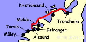
Punctually, the Hurtigrute restarts its way at the mighty Trondheimfjord that extends with a total length of 170 km and a width up to 25 km from Trondheim far into the north west. Still in the range of vision of the harbour and shortly after the cast off, the island Munkholmen is passed. In the medieval times, the abbey Nidarholm stood there, that was not rebuilt any more after the burning in the year 1531. The last traces disappeared when in the 17th century, Nidarholm became a fortification; When the Swedes conquered Trondheim from 1658 to 1718, it was fiercely fired off from 26 cannons, but the shots were not capable to reach the country. The descendants of the vikings obviously lost their warlike talent. Today, Munkholmen is conquered by excurtionists and bathing tourists if there is nice weather. Before the fast steamer reaches the exit of the Trondheimfjord, that is continously getting more narrow in the west, a big bay opens at the backboard side. Here is the homeland of the daughter of Kristin Lavran, the central character of the same named novel of Sigrid Undset. Although the shores of the fjord moved now closer to the the ship, this landscape cannot be measured with the superlatives of the past days. But the forests and agricultural areas, that accompany the course of the Hurtigruten with some low mountains in the background, have something that is exceptionaly beautiful in their piece and quietness. Later on, the light house of Agdenes appears at the backboard, located on a headland. Built in the year 1804 and put out of activity in the year 1984, it is under monumental protection today. Now, the fast steamer turns into southern direction and soon reaches the debouchure of the fjord. We approach the island Hitra at the starboard side and navigate between the island and the mainland into the so called waterway of Trondheim. With 565 km², Hitra is the seventh biggest island of the country and the biggest at the west of the Lofoten and Vesteralen. It is a low and boggish island and in the interior, it is nearly uninhabitated; Alongside the coast, there are fishing villages in which since the 70s, trout and salmon farms have developed to be the most important economic factor. In the forest and the bog area of the island, there is a big deer pack. The huntiung quota of approximately 300 animals per year is, form the economic point of view, not to be sneezed at. 
On approximately half of the waterway of Trondheim, there is the big gas terminal of Tjeldbergodden located on the mainland. A pipeline with a length of 245 km on the sea ground leads to the oil platforms Heidrun, Draugen and Midgard. 
Once the island Hitra is passed, the wide Ramsöyford opens to the west with the flat island area of Smöla. The highest elevation there is only of 68 m. In the island Edöy thsat is not far from the waterway, there is a stone church that was built in the year 1190. A little further to the south west there is then the island Kulöy. There are immature gravesites and a stone arranged with rune inscriptions from the time of the christianization of Norway. In the island, there is a copy, the original is in the University Museum in Trondheim. 
In a strong contrast to the flat island world of Smöla at the starboard, in the waterway at the portside, a mountain conus rises up for more than 900 m. They belong to the tree islands Ertvagöy, Stabben and Tustna. This drastical difference in the altitude profile is due to a cleft in the earth's crust originated in the dark ages that nearly made the islands in the west sink. A component of this is also the archipielago Grip. At the south of Smöla and located 14 km in the north-west of Kristiansund, the 80 little islands and skerries could be easily overseen from the fast steamer if there was not the light house. It guards the islands that partly have strange names as devil, murder or priest. 
From all these islands, Grip is the only one that is populated. At best times, 400 people lived here whose houses clung to a little wodden church from the 15th century to look for some protection against the bad powers of the sea. This protection was also needed, as more than once, the island was inundated, in the years 1796 and 1804, only the church remaned. In the year 1974, the last inhabitants left their island. Today, the houses are used as a holiday domicile and many a couple got married at the little church of Grip. Meanwhile, our ship has approached the Kristiansund with a population of 17.000 inhabitants. The first houses on the smoothly ground rocks appear and soon, also the Sörsund bridge of a length of 430 m that forms the gate to the harbour. The place extends over three islands, that are communicated over bridges to the the mainland. With its communication to the mainland, the city is included in the coastal road, that is nearly free of ferries, from Stavanger over Bergen, Alesund and Molde to Trondheim. This street has already devoured enormous amounts that radicaly changed the flow of goods alongside the coast. Due to the reason that the numerus fjord ferries are getting needless, the places, that were once originated at this intersection, are now aside. This politics that are favourable to the car traffic also had an effect on the Hurtigruten (see History of the Hurtigruten). But one man's meat is another man's poison. case, Kristiansund is going to make profit of this development, as only due to the straight connection with Molde, an economic area was originated in which after all, 100.000 people live. If the matter are economical changes, this city that, in the year 1742 obtained the commercial law, was always able to adapt to the changed cirsumstances. Starting in the 17th century with the wood trade that was actively done with the Netherlands. Then, the trade with the herring began, when this market did not boom any more due to the lack of "raw materials", people changed it to cod. At the end of the 17th century, the dutch man Jappe Ippes settled down here and started to produce cured cod, that was dried on the abundant rocks. Businessmen from England and Scottland settled down in this city and, in the course of the time, countless ships started their way to the Mediterranean Sea with "el bacelo", a dried delicacy of the lent. Earth and gravel were brought back as ballast that was cleared in the bay of Gomalandet. There, the rocky city got its oldest cementary. Still today, a major part of the dryed cod export goes through Kristiansund and the fish processing is still an important economical factor for the city, but in the course of the time, people also built up additionally main pillars in other industrial sectors. Thus, it became, for example, also the supporting point of the oil and natural gas gathering for this coastal region. 
In the year 1940, the city was destroyed by bombs, 724 houses fell victim to this attack. The old Kristiansund mainly disappeared, but could keep its character after the rebuilt. The city arises from the water terrace-shaped up and the little passenger ferries are still, despite of the bridges, important means of traffic between each of the islands and are used as the trams and buses elsewhere. 
Unfortunately, the stay of the Hurtigrute is only short, there is nearly no time for a walk. Once the fast steamer cast off, one should get the camera ready, as also during the entrance into the harbour before. Many a worthwhile motif is to be discovered also from board. Beside the dock facilities, fishing boats and the old warehouses, the nordland-church built in the year 1914 cannot be overseen and on smooth ground rocks, houses are standing which proprietors do not need to worry of the garden designing due to the composition of the ground . After repassing the bridge over the Sörsund, soon, the beacon of Stavenes is visible at the backboard. There, the fast steamer turns to the south and continues its way over the open sea stretch of Hustadvika to Molde. We hope that the powers of the sea are peaceful. 
But ptobably, one decided in Kristiansund to take part on the last country excursion of this journey that goes alongside the coastal road of the Hustadvik - Bay to the idyllic fishing village Bud, that was in the 16th and 17th century the biggest trade place between Bergen and Trondheim war. After a short stay, we drive further to the Romsdalfjord and to Molde, were we go again on board of the Hurtigrute. 
When the Hurtigrute leaves the "City of Roses", the last evening on board already began a couple of hours ago. One is probably sitting together with some new and old acquaintances in one of the saloons, at the bar or cafeteria, discusses about all the world and his brother, talks about the ending journey, plays cards or takes a book, so that the novel is finally finished. Anyhow, half amount of the books brought to the journey could have been left at home. Maybe one spends the time at the deck and experiences, depending on the season, the last sunset on board or a starry nordic night. In any case, there is no hurry to go to sleep in this last evening. Shortly before midnight, Alesund is reached and latest after an one-hour stay there, it is time to go to bed. Maybe, one dreams of the next journey with the Hurtigruten and he knows that it already happened sometimes, that dreams come true... 
back to the index Norway-Hurtigruten Author: Manfred Hofmann; Copyright: Patrick Wagner, www.tourist-guide.biz |
||